COSPAS-SARSAT |
COSPAS-SARSAT is an international satellite-based search and rescue system established by the U.S., Russia, Canada and France to locate emergency position indicating radio beacons (EPIRB's). The COSPAS-SARSAT system operates with both low Earth orbit (LEO) satellites as well as geostationary (GSO) satellites on the frequencies 121.5 MHz and 243 MHz and in the band 406-406.1 MHz. A 406 MHz EPIRB is required for GMDSS.
COSPAS-SARSAT is expected to cease detecting alerts on 121.5 and 243 MHz by 2008.
COSPAS (COsmicheskaya Sisteyama Poiska Avariynich Sudov) is a Russian acronym for Space System for Search of Distress Vessels and SARSAT means Search and Rescue Satellite-Aided Tracking.
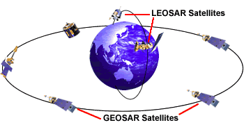
The COSPAS-SARSAT uses both geostationary search and rescue (GEOSAR) satellites and low earth orbit search and rescue (LEOSAR) satellites. The geostationary satellites see a large part of the world. These geostationary satellites provide immediate alerting and identification of 406 MHz beacons. However, the GEOSAR satellites are not able to determine the location of the beacon. They can, however, provide immediate alerts. Ideally, a SARSAT or COSPAS LEOSAR satellite will fly over the beacon within the next hour and calculate the location. Calculation of the location is done by a measurent of the frequency shift due to the speed of the satellite in relation to the beacon (a Doppler shift). The satellite system can detect the location of the EPIRB with an accuracy of 2 to 5 km. There are also 406 MHz EPIRB's available with an integrated GPS navigation receiver. These EPIRB's will send an accurate location.
|
| © NOAA |
The following satellites are used.
Low-Earth Orbiting Search And Rescue (LEOSAR) Satellites
Geostationary Orbiting Search And Rescue (GEOSAR) Satellites